USGS bores to bedrock in Falmouth
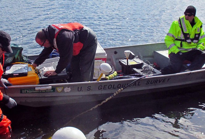
USGS Geological Survey Scientists Carol Johnson, Eric White and Tim McCobb prepare to deploy geophysical equipment in a coastal embayment April 9, 2015 in Falmouth, Massachusetts. This equipment will outline the geological conditions under the water, which will give the scientists a better understanding of the geology and hydrology of the sandy glacial deposits underlying this portion of Cape Cod’s coast.
USGS bores to bedrock in Falmouth
Groundwater modeling work performed under an agreement between the Cape Cod Commission and United States Geological Service is offering a glimpse of groundwater below parts of Falmouth.
USGS Hydrologists Denis LeBlanc and Tim McCobb provided an update of their work to Commission Water Resources staff on the Cape Cod groundwater project,.
Last year, the Commission and USGS agreed on a program of work that included groundwater investigations in the Falmouth area to help set baseline data related to water quality improvement projects.
The Commission and USGS have partnered on a number of projects , including the recent report, “Potential Effects of Sea-Level Rise on the Depth to Saturated Sediments of the Sagamore and Monomoy Flow Lenses on Cape Cod, Massachusetts,” by Donald A. Walter, Timothy D. McCobb, John P. Masterson, and Michael N. Fienen, (https://pubs.er.usgs.gov/publication/sir20165058). The study was done in cooperation with the Commission, Association to Preserve Cape Cod, the Massachusetts Environmental Trust and the Nature Conservancy.
The study found that the water table on Cape Cod could rise by about two feet, on average, in response to a six-foot sea-level rise, the level some models predict will occur by 2100. The potential rise in the water table is less than the potential rise in sea level because the Cape’s streams and wetlands are expected to dampen the water-table response, which likely would mitigate some of the effects of sea level rise in inland areas.
Boring to bedrock in coastal Falmouth
A boring was completed to bedrock at the East Falmouth Elementary School on Davisville Road. Cores were collected from land surface to 312 feet. The unconsolidated glacial sediments are 307 feet thick consisting of about 100 feet of sand and gravel that overlies about 170 feet of gray silt and fine sand and 30 feet of gray medium sand. The medium sand rests directly on granitic bedrock. The water table was encountered at about 30 feet, and saline groundwater was encountered at about 100 feet. Tom Cambareri says, “The results are particularly useful to researchers and planners in evaluating the transport of nitrogen through the aquifer into the surrounding coastal waters. Conceptual models of deep groundwater flow used for most of Cape Cod are based on too few data points at the coastal interface. This provides actual stratigraphic information on our aquifer and depth of fresh water, and many of us were surprised by its shallow depth in this location.
Analysis of testing done in the borehole is underway. Surface geophysical measurements were made near the borehole.
The USGS team from the New England Water Science Center, the Office of Groundwater Branch of Geophysics, and the Eastern Region Earth Processes Group are preparing a USGS report describing the borehole and subsequent hydrologic, geologic and geophysical observations and tests.
Maravista Water Monitoring
Other work includes water quality monitoring of groundwater beneath Falmouth’s Little Pond sewering project. The project consists of the installation of a network of 18 monitoring wells and 14 multilevel sampling devices.
Work continues installing sewers to connect approximately 1,400 properties to a town collection system and remove existing onsite septic systems. Groundwater samples were collected to obtain baseline water-quality data prior to the connection of the sewers in 2017.
The wells and sampling devices are arranged in four transects that cut across the 1,600-foot-wide peninsula. Sediment cores were collected for grain-size analysis at four sites.
Water levels were measured in the monitoring wells and in the two adjacent saltwater bays. A water-table map was prepared from the water levels and GPS and differential leveling.
Samples were analyzed for field characteristics and sent to a laboratory for analysis of nitrate, ammonium, chloride concentrations. The data indicate that the freshwater lens beneath the peninsula is about 25 feet thick. Concentrations as high as 18 mg/L nitrate as nitrogen were measured in the groundwater samples. Cambareri says, “ the baseline data will be compared to post sewering conditions to evaluate how long it will take groundwater quality to improve. This is new straightforward approach to compliance and adaptive management monitoring for nitrogen reduction sewering projects.”
Additional samples will be collected for analysis of selected pharmaceutical and personal care products and other emerging contaminants. This sampling is supported by the Environmental Protection Agency and the USGS Toxic Substances Hydrology Program.
The USGS provided 100 percent of the funding for this agreement. The work was also supported by the Environmental Protection Agency, the USGS Toxic Substances Hydrology Program, and the USGS Office of Groundwater.
Related Posts