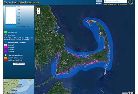
Explore the Cape Cod Commission’s Sea Level Rise Viewer
June 1st marked the official start of the Atlantic hurricane season. The National Oceanic and Atmospheric Administration (NOAA) is expecting an above-average year. Thirteen to 19 named storms are predicted, and three to six of those could become hurricanes. Activity began early this year with two tropical storms, Arthur and Bertha, forming in the month of May.
Tropical storms and hurricanes not only bring strong winds, they also cause storm surge and flooding. Cape Cod is especially vulnerable to the impacts of storm surge and sea level rise.
Cape Cod Commission staff developed the Sea Level Rise Viewer, a web mapping application and visualization tool to illustrate the vulnerability to climate change hazards related to significant meteorological events.
You can use this tool to see predicted sea level rise scenarios, sea and lake overland surges from hurricanes (SLOSH), as well as the Federal Emergency Management Agency (FEMA) flood rate insurance map (FIRM).
Also shown are the town-identified critical facilities for the entire Cape, and the potential effects of sea level rise on the road network.
Explore the Sea Level Rise Viewer
View video summary of predictions from NOAA:
Related Posts