Overview
As a service to Cape officials, engineers and other interested parties, the Cape Cod Commission publishes monthly data about water levels at groundwater observation wells on Cape Cod. The data provide current information for the effective siting of septic and stormwater management systems and give historical context for year to year fluctuations in the regional water table. Past records on selected wells extend back to the 1950s.
The water level measurements shown below are taken monthly from United States Geological Survey (USGS) observation wells. They are compiled during the last week of each month and are published as soon as possible thereafter.
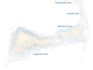
Listed below are ten out of the 32 wells measured across Cape Cod by the Commission's Water Resources staff. These ten are employed as index wells to be used with Technical Bulletin 92-001: Estimation of High Groundwater Levels for Construction and Land Use Planning to predict high groundwater levels. The USGS maintains records of this data as part of its National Water Information System (NWIS) network. Links to the NWIS records for each well are located in the last column of the table.
Other Resources
The High Groundwater Levels Data Viewer is the most up-to-date and accessible data resource for users to determine high water levels across the Cape. The Viewer incorporates measurements for all current index wells and corresponding adjustments from the updated adjustment tables.
LINK: Past Well Data
Contact
-
Tim Pasakarnistim.pasakarnis@capecodcommission.org
-
Tara Nye Lewistara.lewis@capecodcommission.org